Bizer's list of islands of Lake Winnipesaukee
Updated 19-August-2017So far, the count is 264, only 134 are over 1/4 acre)
There has been a lot of controversy about the number of islands contained within Lake Winnipesaukee. Folklore has it that there are 365 islands, one for each day of the year. Another source says that there are 274 inhabitable islands. So Bizer is attempting to generate a complete list of all the islands within Lake Winnipesaukee AND WE NEED YOUR INPUT. We want to know anything to make this list more complete, such as: Omitted Island; Alias for an island; Unusual History or trivia about an island. If you have anything to add to this list, please send us an email. Recent changes to this list are at the bottom.
Our first task was to define what constitutes an island. What is the dividing line between a large rock and a small island? When does one island become two? Well, this is our definition; your results may vary: It must be surrounded by water at high lake in June; It must have vegetation (otherwise it's just a rock); Man made breakwaters do not count as islands, BUT we do count former natural islands where fill has been added to join two land masses; There must be at least a three foot height difference between the island's tallest point (including vegetation) and the surrounding water's shallowest depth (e.g. if the surrounding water is only 14 inches deep, the island must rise at least 22 inches above the surface).
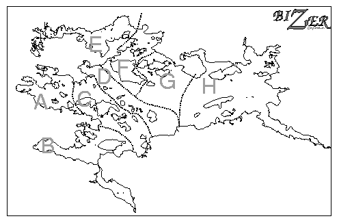
Then, we divided the lake into eight regions for grouping. We tabulated islands within that region in some geographical order. Here is a map of the lake divided into the eight regions, "A" through "H".
Listed here are the approximate sizes of each island, its name, its location, and any other descriptive information that identifies the island. If an alias or old name is also known, that name, too, is listed. For ease of counting, islands are placed into groups of ten.
Bizer is looking for input to complete this list.
If you have anything to add to this list, please
email us
at Island2020@bizer.com.
We want to find out how many islands there really are.
Some notes, assumptions, and abbreviations that are used here:
The sizes listed here are eyeball-estimates.
Size = 1 - Under   3m square (e.g. Becky's Garden)
       2 - Under  10m square
       3 - Under  30m square (under 1/5 acre) (Minimum size for a shack)
       4 - Under 100m square (under 2 acres) (Minimum size for a septic system)
       5 - Under 300m square (under 20 acres)
       6 - Under  1km square (under 200 acres)
       7 - Over   1km square
Go to
Bizer's Home Page
 Section A:
Center Harbor to Brown's Boat Basin to Avery Point.
Starting at Shep Browns Boat Basin to the channel mid way between
Bear Island & Pine Island to Avery Point (ESE of Hull Island).
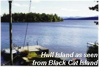
- - - Photo: Hull Island as viewed from Black Cat Island.
Section A:
Center Harbor to Brown's Boat Basin to Avery Point.
Starting at Shep Browns Boat Basin to the channel mid way between
Bear Island & Pine Island to Avery Point (ESE of Hull Island).
- - - Photo: Hull Island as viewed from Black Cat Island.
Size Name ...._...... Location/Comments
 5   Wallace          NE BlackCat.I, E of FL#54
 1   (Unknown)-A01    600m NE FL54, Just NW Senter Cove
 5   Krainewood       The end of Krainewood Drive passes over small channel to Salmon Meadow Cove.
 1   (Unknown)-A02    N'ern of 2 small islands just S Ash Cove; 575m NW FL#54 (White Pines?)
 1   (Unknown)-A03    S'ern of 2 small islands just S Ash Cove; 550m NW FL#54
 1   (Unknown)-A04    Small island off 2nd neck, 450m NW FL#54
 1   Little Plum      675m SW FL#54; Just NE of bridge to Black Cat.I
 6   Black Cat        200m NNW FL#83
 4   Blueberry        E Black Cat.I; 850m NE FL#83 - {AKA Minister.I)
 5   Hull             500m E FL#83; SE Black Cat.I
 10-------------------
 1   Becky's Garden    W Black Cat.I;300m E FL#06
 4   Two Mile         2 miles from Center Harbor
 3   (unknown)-A07    220m N FL#06; Just W of 2-mile (1 of 2)
 3   Little Two Mile  300m N FL#06; Just W of 2-mile (2 of 2)
 4   Harvard?         Mouth of Blackey's cove; 500m ENE FL#05
 1   Harvard#2?       Between Harvard Island and First Neck
 4   Eljays           In Blackey's cove, 450m NNW Harvard.I
 4   #48 Shoreline    In Blackey's cove, 800m N FL05, 275m NW Eljays.I
 2   Little One Mile  BT FL#5 and First Neck; 20m NE FL#5
 5   Hog              Western of two, 0.5 miles from Center Harbor.
 20-------------------
 5   Half Mile        Eastern of two, just SW from two black buoys.
 5   One Mile         West of FL#5, entrance to Center Harbor
 3   West One Mile    Separated from One Mile Island by 2m wide channel.
 3   Little Loon      Off Leavitt Park
 6   Big Beaver       ENE Hornet's Nest Pt; Largest Island in cluster
 4   Middle Beaver    NNE Big Beaver
 4   Little Beaver    NE  Big Beaver
 5   Beaver           ENE Big  Beaver
 6   Three Mile       S of Black Cat.I
 4   Hawk's Nest      East of Three-Mile-Island
 30-------------------
 2   Nabby's          BT Hawk's Nest.I and Three.Mile.I
 3   Rock #3          20m E Three Mile.I; 600m S FL#83
 3   Goose            BT Pine.I and Meredith Nk
 3   Loon #1          S Pine I (There are 3 Loon Islands in Winnipesaukee)
 1   Loon Is. Landing 10m west of Loon#1, connected by footbridge
 6   Pine             South of Three-Mile-Island; 300m W FL#04

     36 Islands in section A
If you have anything to add to this list, please
email us
at Island2020@bizer.com.
Return to index
Size Name ...._...... Location/Comments
 4   Little           In Paugus Bay, W of FL#60
 5   Big              In Paugus Bay, ESE of FL#39 {FKA Two Mile I} {Labeled Goat I. in an 1891 map}
 5   Christmas        Northern end of Paugus Bay {FKA Plummer's I}
 3   Pixie            Just WNW of Christmas Island
 1   Thurstons#1      Northernmost of teeny islands at Thurston's Marina
 1   Thurstons#2
 1   Thurstons#3
 2   Indian           Just NE Inn at Bay Point, Meredith
 4   (unknown)-B05    At Meredith Yacht Club
 1   Unknown-B10      950m NW of Spindle Point in Meredith Bay
 10-------------------
 1   Unknown-B11      320m NW of Spindle Point in Meredith Bay
 5   Oak              800m N of Spindle Point, S Boardman's Pt
 4   Hen              NE Oak.I (a.k.a. Gypsy)
 1   Gull Rocks       A pile of rocks above water, 250m ENE of Hen I
 5   Pitchwood        N of FL#44
 3   Welcome          Bt Pitchwood I & Stonedam I {AKA Wilcomb I}
 3   Isle of Pines    North of Welcome; 550m NE FL#44
 6   Stonedam         Between Pitchwood I and Meredith Neck
 4   Ledge            BT Stonedam I and Fish Cove
 3   Dale             300m SW Ledge I
 20-------------------
 2   (unknown)-B16    400m NNW FL80, just off Meredith Neck
 2   (unknown)-B17    20m W of Lone Pine Pt
 7   Governor's       NE of FL#69
 4   Eagle            Between Governor's I and Pitchwood I

     24 islands in section B
If you have anything to add to this list, please
email us
at Island2020@bizer.com.
Return to index
 Section C:
Cooks Point to Five-Mile, Bear, Timber, and Lockes Islands to Glendale.
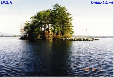
Islands are listed from north to south. - - - Photo: Dollar Island
Section C:
Cooks Point to Five-Mile, Bear, Timber, and Lockes Islands to Glendale.
Islands are listed from north to south. - - - Photo: Dollar Island
Size Name ...._...... Location/Comments
 6   Five Mile        SW of Long Pt, SE of FL#57
 7   Bear             NW FL#30
 4   Little Pine #1   NE of four islands, S of Jerry Pt, Bear I
 4   Rock #1          NW of four islands, S of Jerry Pt, Bear I
 4   Palmer           SE of four islands, S of Jerry Pt, Bear I
 4   Shepard          SW of four islands, S of Jerry Pt, Bear I
 2   Mother-in-Law    One step from Bear I; 1425m N FL#03; 100m SE Little Pine
 2   Unknown          20m off Meredith Neck; 1550m NNW FL#03 (New, Oct-2013)
 4   Dollar           350m E Bear I
 5   Dolly            Just off Bear I, 420m NE FL#3; 1080m WNW FL#29
 10-------------------
 4   South Dolly      Just E Dolly I. (see notes)
 4   Little Dolly     just S South Dolly.  South Dolly & Little Dolly have a small channel cutting it into two islands.
 2   Penny            Large rock just NE South Dolly; 500m NE FL#03 (Formerly thought to be Piano Island)
 1   Piano            Large rock 25m E Little Dolly; 25m SE South Dolly
 3   Horse            120m NW FL#03
 6   Mark             Just S FL#29
 2   Little Mark      West side of Mark; 225m SW FL#29
 6   Mink             S FL#30, SE Mark I
 7   Timber           S Mark I, N of FL#28 {FKA Wentworth I}
 2   Unk (1 of 2)     In Cove on NE side of Timber I. 1275m SE FL#70
 20-------------------
 2   Unk (2 of 2)     In Cove on NE side of Timber I. 1275m SE FL#70
 6   Round #1         E of FL#08, SW of FL#46;  {FKA Smith's Island}
 6   Lockes           NE of FL#53, NNW of Glendale {FKA Thompsons Little I}
 4   Rock #2          E of Lockes; NW of FL#26; {FKA Ford's I}
 4   Pig              SSW of Lockes I, Opposite Marine Patrol Headquarters
 4   (Unknown)-C25    Inside the Silver Sands gas dock next to the
                      Silver Sands Motel
26 Islands in section C
If you have anything to add to this list, please
email us
at Island2020@bizer.com.
Return to index
Size Name ...._...... Location/Comments
 5   Hermit           At northern tip of Braun Bay
 5   Glines           Largest Island in Braun Bay
 3   Goose            500m NW of Glines I
 5   Six Mile         N of FL#"7"
 1   Less-in-Area     BT FL#6 and Little-Six-Mile I
 4   Little Six Mile  300m E of FL#7, SE of Six-Mile I (FKA Crescent I)
 1   (unknown)-D07    BT Little Six Mile I & Ozone I
 4   Far Ozone        200m SE Little Six Mile I {AKA Ozone I}
 6   Birch (1 of 2)   N FL#45 [Another Birch I is N FL#72]
 4   Steamboat        Connected to Birch I by a walking bridge
 10-------------------
 6   Jolly            S FL#45 {FKA Foley}
 5   Little Camp      920m E FL#30; {FKA Camp I}; (see notes)
 6   Camp             E Mink.I; NE Round.I         {FKA Follet I}
 5   Kinneho          SE Camp I; (see notes)
 4   Breezy           SW Kinneho, 480m E FL#46
 5   Crescent         SE Kinneho; (see notes)
 2   Saint's Rest     W of Crescent I; 720m W FL#46
 2   LeRoy            S of Crescent I; 880m W FL#46; BT Crescent I & Fish I
 5   Fish             S Crescent I {FKA Morrison I}
 4   Pop              W Fish I (Not Pops)
 20-------------------
 7   Welch            NW FL#47 {FKA Thompson's Great; FKA Fischer's I}
 2   Frawley Park     Eastern of two small islands in cove on W side Welch I
 2   Raccoon          Western of two small islands in cove on W side Welch I

     23 Islands in section D
If you have anything to add to this list, please
email us
at Island2020@bizer.com.
Return to index
Size Name ...._...... Location/Comments
 1   The Big Rock     Large rock at north end of Green's Basin
 4   Starr            Southern end of Green's Basin
 4   Little Goodwin   On N side channel, entrance to Green's Basin
 2   Lump             Between Little Goodwin & Goodwin
 5   Goodwin          N Little Goodwin I - This may not be an island,
                      but you can't get to it without walking in 50m of muck.
 5   Badger           E Goodwin I
 4   Little Badger    Point surrounded by marsh, 200m NE Badger
 4   Round #2         SSE Badger I, & N of the channel going to Green's Basin
 2   Turtle           Large rock S of black buoy, 220m ESE Round I
 3   Battleship       400m NW Blanchards I; 40m S Little Badger
 10-------------------
 4   Blanchards       At entrance to Raoul's Cove; 550m SW FL#52; FKA Girl Scout Island
 4   Evergreen        W Bryant's Pt; 350m WNW FL#52
 3   Blanche          Island with camp, 300m NW Evergreen I
 2   Little Pine #3   5m W FL#51;  FL#51 is at the edge of this island.
 2   (unknown)        8"x24" island with footbridge 180m NNE Hemlock Point I.
 4   Hemlock Point    120m ENE FL#51; (see note) for Goodwin I
 2   Small            75m N FL#51, across channel.
 2   (unknown)        5m wide island between Small & Little Pine (#2)
 3   Little Pine #2   160m ESE FL#51;(see notes)
 5   Pinehurst        SE Bryant's Pt; 150m SW FL#51
 20-.-----------------
 4   Basin            150m W Whaleback (formerly thought to be Loan's Island)
 4   Whaleback        5m NE FL#50; {AKA October Morn}
 4   October Eve      Northern part of Whaleback Island, separated by footbridge
 2   Outlaw           10'x20' mini island just SE Whaleback
 5   Whaleback Point  12-14 acre; NNE Whaleback Island; marginal island
 1   Unknown-E06      Northeastern of 2 small islands in cove on SE side Whaleback Point Island
 1   Unknown-E07      Southwestern of 2 small islands in cove on SE side Whaleback Point Island
 5   Spring           450m S Balmoral beach; 820m NE FL#50
 4   Little Ganzey    350m NW Ganzey I; 500m E FL#50
 4   Guay             200m SW Little Ganzey I; 420m SE FL#50
 30-------------------
 1   (Unknown) E51    Tiny island between Guay I and the mainland
 6   Ganzey           Between Suissevale & Balmoral; (see notes)
 3   Half-Acre        Just E Ganzey I
 5   (unknown)-E22    Land with conduit under road, NW Birch I
 5   Birch (2 of 2)   S Suissevale [another Birch I just N FL#45]
 2   Unknown-E24      Northern tip of Birch Island is a separate island
 1   Unknown-E25      450m SE Birch I.
 4   Lincoln          SW Birch I
 3   Cosy             SW Lincoln I {AKA Shady}
 1   Unknown-E26      1 of 2 tiny islands 360m N FL#72, off Hemlock Pt.
 40-------------------
 1   Unknown-E27      2 of 2 tiny islands 360m N FL#72, off Hemlock Pt.
 3   Children's       In Ambrose Cove; 250m W Black Pt; FKA Arey's Island
 4   Randall          320m NW FL#14; S of black buoy
 5   Marra            200m W FL#14
 4   Small            200m SW FL#14 (Town of Moultonborough)
 5   Cove (#1)        Island in middle of Buzzel Cove is Cove Island
 2   Loon #2          1000m S FL#14
 6   Joe's            550m SSW Loon#2, SW of Smith Cove
 5   Poplar           SE Joe's I;
 2   (unknown)-E34    Northern of 2 very small islands, western end Landgon CV
 50-------------------
 2   (unknown)-E35    Southern of 2 very small islands, western end Landgon CV
 2   (unknown)-E36    About 20 feet offshore at 17 Geneva Point Road, Moultonborough
 4   Gun              530m NNE FL#13
 4   Goose Egg Rock   500m SW FL#12 {Hartshorn I on assessors' map}
 3   (unknown)-E38    200m SSW Goose Egg Rock
 3   (unknown)-E39    200m SE Goose Egg Rock
 4   Wentworth        300m SE Goose Egg Rock
 1   (unknown)-E41    Surrounded by four buoys 580m ESE FL#12
 4   Gem              Western of two islands called "Twin Islands"
 4   East Twin(?)     Eastern of two islands called "Twin Islands"
 60-------------------
 4   Store            880m N FL#59; in Melvin Bay
 6   Black            600m WNW FL#59

     62 Islands in section E
If you have anything to add to this list, please
email us
at Island2020@bizer.com.
Return to index
 Section F:
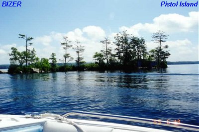
Fl#59 & Nineteen Mile Bay to Dow Island to Long Island. Photo: Pistol Island
Section F:
Fl#59 & Nineteen Mile Bay to Dow Island to Long Island. Photo: Pistol Island
Size Name ...._...... Location/Comments

 6   Farm             Nineteen Mile Bay, 900m ESE FL#11
 6   Chase's          NW Farm I; 600m E FL#11 {Labeled Grace's I. in an 1891 map}
 5   Melvin           200m W FL#11; {AKA Little Huck}; (see notes)
 2   Little Huck      Off Southern tip of Mevin I; 250m W FL#11
 4   Spectacle (N)    820m SSW FL#59.  There are two parts to Spectacle I
 4   Spectacle (S)    S of Spectacle (N) - Connected by rocks at surface
 4   Pistol           120m SSE FL#81; one of the smallest islands w/ house
 6   Nine-Acre        300m NW FL#81;
 2   (unknown)-F08    120m NW FL#81; just off Nine-Acre I (1 of 2)
 2   (unknown)-F09    120m NW FL#81; just off Nine-Acre I (2 of 2)
10-------------------
 3   Perch            480m W FL#81; Just SW Nine-Acre I
 2   North Pasture    100m W Perch I; 620m W FL#81
 6   Whortleberry     900m S FL#81
 1   Unknown-F11      Just off Eastern tip, Whortleberry; 500m NW FL49
 6   Dow              NW Whortleberry I
 3   (unknown)-F12    Just NNW Dow; 1180m E FL#64; 1380m N FL#58
 2   Cove (#2)        In cove just S Whortleberry I; 650m W FL#49
 4   Chip             1st of 4 in chain W of Whortleberry.I;800m ENE FL#58
 4   Helen            2nd of 4; 650m ENE FL#58
 5   Little Whortleberry - 3rd of 4;500m ENE FL#58
20-------------------
 3   Hurricane        4th of 4; 300m NE FL#58
 5   Pleasant         Just S Dow I; 500m N FL#58
 4   Tip              720m E FL#58; Off SW tip of Whortleberry I
 7   Long             Connected by bridge to Moultonboro Neck
 1   Campers          Large rock w/ bushes 100m N Long I. Bridge
 4   Foley's          400m E Long I. Bridge
 2   Blueberry        Just SE Foleys I; 800m NW FL#64

27 Islands in section F
If you have anything to add to this list, please
email us
at Island2020@bizer.com.
Return to index
Size Name ...._...... Location/Comments
 6   Sandy            500m SE FL#09
 5   Ragged           600m E FL#77
 3   Little Pine Tree a.k.a. Barrett.I; 425m SW FL#41; BT Ragged I & Cow I
 3   Little Ragged    240m WSW FL#41; 200m N Little Pine Tree I
 2   Drew             Off NW tip Ragged I; 600m SW FL#65;(see notes)
 7   Cow              300m NE FL#41 {FKA Guernsey I}
 4   Rocky Ridge#1    One of three islands 550m NNW FL41; just off Cow I
 3   Rocky Ridge#2    Two of three islands 550m NNW FL41; just off Cow I
 2   Rocky Ridge#3    Three of three islands 550m NNW FL41; just off Cow I
 1   Unknown-G06      Just off Cow I; 180m N FL#41
 10-------------------
 4   Blueberry        580m SE FL#41; 1 of 2 collectively called Cove Island
 4   Little Blueberry 580m SE FL#41; 2 of 2 collectively called Cove Island
 3   Turtle           400m SE FL#41
 5   Devens           BT Cow I & Little Bear I; 280m ENE FL#65;(see notes)
 6   Little Bear      100m SE FL#10 {AKA Samoset I}
 4   Squirrel         200m W FL#17
 5   Little Birch     280m SW FL#17
 4   Little Cove      In Orchard Cove; 1100m NW FL#18
 4   Loon #3          420m W FL#18
 4   Echo             920m W FL#18
 20-------------------
 4   Windswept        1200m S FL#41; off SW Cow I

     21 Islands in section G
If you have anything to add to this list, please
email us
at Island2020@bizer.com.
Return to index
Many islands in this section are difficult to define. In order to boat around Melody Island, one must also boat around at least one dozen other islands: Three on the east side of Melody; Two south of Melody Island (and connected by rocks); five unbuildable islands (Are these the Varney Islands?), and one very small island which may be considered a rock.

Size Name ...._...... Location/Comments
1 (unknown)-H01 N of Tuftonboro Neck; 480m WNW FL#15
5 Parker At FL#20
4 Grant 1900m ENE FL#40
5 Worcester 1300m E FL#40
2 (unknown-H05) Off north side of Worcester Island
2 Cove Just SE of bridge to Worcester I.
5 Melody 580m E FL#40 FKA Big Mud Island (The next 11 are grouped w/ Melody I)
2 Shelter Hugs E side Melody I; 320m from N'ern tip, Melody I
3 Uppershoe Off E side Melody I; 480m from N'ern tip, Melody I
(Shown as Upper Shoe in photogtaph)
3 (unknown)-H16 Just S Uppershoe; 520m from N'ern tip, Melody I
10-------------------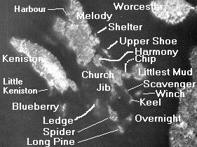 5 Harmony Just S Melody I; on chart, looks part of Melody.I
4 Littlest Mud 1100m ESE FL#40
4 Chip 1040m ESE FL#40
4 Church Just SE Harmony; connected to Harmony by rocks (FKA Mud Island)
3 Jib See photo
2 Harbour See Photo
2 Little Keniston SW side of Keniston
2 Ledge Large Rock 300m S Melody I; 200m SE Keniston I
3 Spider See photo
2 Long Pine See photo (One source calls this Nasbob Island)
20-------------------
2 Overnight See photo (One source calls this Long Pine Island)
2 Keel See photo
2 Winch See Photo
2 Scavenger See photo
6 Keniston At FL#40 (FKA Waveland I)
3 Little Blueberry W/ house, just S Keniston I; 650m SSE FL#40
5 Little Barndoor 200m ESE FL#66
6 Barndoor 900m SE FL#66
4 Little Vixen At southern tip, Barndoor I; 850m S FL#40
4 Plum Roberts Cove; 420m SE FL#74
30-------------------
3 Quarter-Mile In Roberts Cove; 100m E FL#79
4 Loon (#4) Just S Sandy Point, Alton; 380m SW FL#23
3 Mt. Major SE'ern of 2 islands, Woodmans Cove; 2280m NNW FL#23
3 Canney's NW'ern of 2 islands, Woodmans Cove; 2320m NNW FL#23 (AKA Woodman's Cove Island)
4 Little Mark 100m NW FL#22
3 Moose 120m N FL#78 {Labeled Varney's I. on an 1891 map}
3 Ship 780m NW FL#78
5 Treasure 200m S FL#24 {FKA Redhead I} {Labeled Red Hand I. on an 1891 map}
2 (unknown)-H30 In Minge Cove; 100m W FL#73
6 Sleepers 800m ESE FL#48 {FKA Little Rattlesnake; FKA Flanders}
40-------------------
4 Cub Just SE Sleepers I; 950m NNW FL#73
3 Pearl In Glidden Cove; 780m S FL#48 (a.k.a. Black Snap Island)
7 Rattlesnake 100m SE FL#25
2 Gichigumi 100m SW FL#48; just off Smith Point
6 Diamond 2100m NW FL#48
45 Islands in section H
5 Harmony Just S Melody I; on chart, looks part of Melody.I
4 Littlest Mud 1100m ESE FL#40
4 Chip 1040m ESE FL#40
4 Church Just SE Harmony; connected to Harmony by rocks (FKA Mud Island)
3 Jib See photo
2 Harbour See Photo
2 Little Keniston SW side of Keniston
2 Ledge Large Rock 300m S Melody I; 200m SE Keniston I
3 Spider See photo
2 Long Pine See photo (One source calls this Nasbob Island)
20-------------------
2 Overnight See photo (One source calls this Long Pine Island)
2 Keel See photo
2 Winch See Photo
2 Scavenger See photo
6 Keniston At FL#40 (FKA Waveland I)
3 Little Blueberry W/ house, just S Keniston I; 650m SSE FL#40
5 Little Barndoor 200m ESE FL#66
6 Barndoor 900m SE FL#66
4 Little Vixen At southern tip, Barndoor I; 850m S FL#40
4 Plum Roberts Cove; 420m SE FL#74
30-------------------
3 Quarter-Mile In Roberts Cove; 100m E FL#79
4 Loon (#4) Just S Sandy Point, Alton; 380m SW FL#23
3 Mt. Major SE'ern of 2 islands, Woodmans Cove; 2280m NNW FL#23
3 Canney's NW'ern of 2 islands, Woodmans Cove; 2320m NNW FL#23 (AKA Woodman's Cove Island)
4 Little Mark 100m NW FL#22
3 Moose 120m N FL#78 {Labeled Varney's I. on an 1891 map}
3 Ship 780m NW FL#78
5 Treasure 200m S FL#24 {FKA Redhead I} {Labeled Red Hand I. on an 1891 map}
2 (unknown)-H30 In Minge Cove; 100m W FL#73
6 Sleepers 800m ESE FL#48 {FKA Little Rattlesnake; FKA Flanders}
40-------------------
4 Cub Just SE Sleepers I; 950m NNW FL#73
3 Pearl In Glidden Cove; 780m S FL#48 (a.k.a. Black Snap Island)
7 Rattlesnake 100m SE FL#25
2 Gichigumi 100m SW FL#48; just off Smith Point
6 Diamond 2100m NW FL#48
45 Islands in section H
If you have anything to add to this list, please
email us
at Island2020@bizer.com.
Return to index
Return to index
Data for this project was gathered from many sources,
some of them conflicting:
Recent changes:
Go to Bizer's Home Page
After compiling the island count, Bizer started to receive requests for other pieces of information such as shore line and area, so we'll share some of that information.
We set our trusty computer to analyze the data that we use to make our map. After adding everything, we conclude that Winnipesaukee is 79.6 square miles. This includes Paugus Bay, The Basin, Back Bay, and all the islands. The islands compromise 8.3 square miles leaving the lake itself with a surface area of 71.3 square miles (79.6 - 8.3). Note: 640 acres = one square mile.
Here are the islands larger than 4 acres, largest first:
Long=1186; Bear=780; Cow=522; Governors=504; Rattlesnake=368; Welch=187; Little Bear=143; Stonedam=141; Timber=136; Sleepers=113; Mark=102; Barndoor=88; Black Cat=75; Pine=74; Whortleberry=69; Sandy=67; Jolly=50; Three Mile=47; Round=43; Lockes=42; Diamond=37; Dow=32; Big Beaver=30; Camp=28; Mink=26; Birch=25; Six Mile=23; Farm=21; Melody=20; Chases=19; Worcester=18; Keniston=18; Pitchwood=15; Ganzey=15; Nineacre=13 acres (Which makes you wonder how Nineacre Island got its name); Five Mile=13; Ragged=12; Badger=11; Treasure=10; Hull=9; Joes=8; Glines=7; Beaver=7; Little Barndoor=6; Little Camp=6; One Mile=6; Little Whortleberry=6; Kinneho= 5; Half-Mile (western section)=5; Christmas=4; Whaleback=4; Fish=4; Half Mile (eastern section)=4;
Largest 53 islands (listed above) = 5198 acres (8.1 square miles)
All remaining islands = 107 +/- acres
Grand Total = 5305 acres (8.3 sq mi)
Only 73 islands are 2 acres or more
18 Islands are 1-2 acres.
16 islands are 1/2 to 1 acre
24 islands are 1/4 to 1/2 acre
14 islands are 1/10 to 1/4 acre
Bizer calculated the Lake Winnipesaukee outer shoreline at 178 miles. This includes Paugus Bay, Back Bay, The Basin. It also includes 1 1/2 miles of shoreline south of the Route 11 bridge in Alton Bay. Together, the islands have 100 1/2 miles of shoreline. Adding these two figures gives Lake Winnipesaukee 278 1/2 miles of shoreline.