Bizer news of Lake Winnipesaukee
Updated 25-Jun-2026

Version 4 of Winnipesaukee/Garmin is now available.
Go to
http://bizer.com/garmin
for the latest progress on
Bizer's
Garmin project.
*** We now have Garmin DataCards, SD cards, or
MicroSD cards pre-loaded with our
Winnipesaukee version W4.
Bizer has increased its $100 REWARD to $250.
Bizer's goal is to find and
chart EVERY shallow area of Lake Winnipesaukee. If you
can find a place that's less than six feet deep that Bizer has failed to mark
in blue, Bizer will give you a reward of $250.00.
- The six foot depth is based on a fall lake level of 503.1 feet.
During periods of lower-than-normal water levels (e.g. summer of 1999), the depths must be adjusted.
- Bizer backs its depth information with cash. The only guarantee that Duncan Press makes is:
if there is a problem, they will replace the chart.
- Bizer offered a reward of $100 from 2001 to 2005 when Bizer's reward was increased
to $250.
Since 2002, Bizer has given four boaters a total of $850 for correcting Bizer's chart.
No correction to Bizer's map is too small.
We don't care how trivial it is.
Maybe you know of a new No Rafting zone.
Maybe you know of a restaurant accessible by boat that recently opened (or closed).
Maybe you know of a new road that's not on our chart.
Maybe you know of a new cell tower (or other prominant object on land) that is visible from the lake.
(Some people navigate by taking bearings on land objects).
email us
at Notify19@bizer.com.
We really do want to make this a perfect product. With your help, we might just do
it.
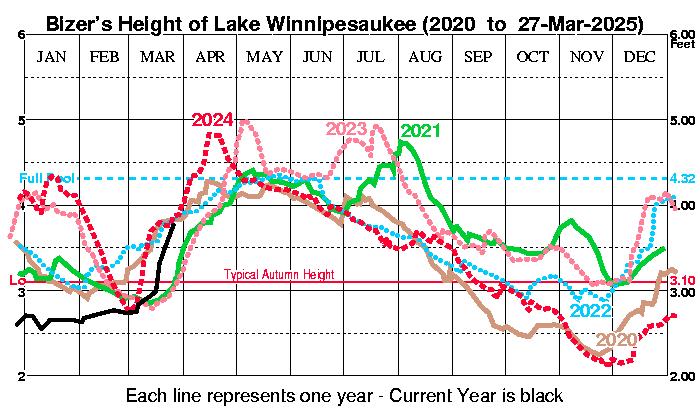
BIZER's Surface level of Lake Winnipesaukee
Lake Winnipesaukee's surface level is measured in feet.
Readings are made daily by the New
Hampshire Department of Water Resources.
The datum (zero point) is 500 feet above sea level. Median heights are
based upon data from
1984 through 2011.
As a rule of thumb,
assume: High Tide: June;
Low Tide: February. Temperature, (F),
readings are taken at the Lakeport Dam
about one foot below the surface.
The below historical statistics are updated
periodically: normally weekly or whenever the lake
level changes unexpectedly by more than three inches.
 2026    Actual  Deviation    Outflow at
 Date    Height  from Norm   Lakeport Dam
--/-- --- ----     --.--  TEMP ---- ---
03/05 Thu 2.98     + .17   34   250 CFS
03/13 Fri 3.06     + .17   34   250 CFS
03/19 Thu 3.39     + .39   36   250 CFS
03/26 Thu 3.64     + .51   37   250 CFS
04/02 Thu 3.91     + .48   38   250 CFS
04/10 Fri 4.17     + .42   39   250 CFS
04/16 Thu 4.29     + .25   42   250 CFS
04/23 Thu 4.50     + .40   42   250 CFS
04/30 Thu 4.52     + .33   47   250 CFS
05/07 Thu 4.56     + .30   47   250 CFS
05/14 Thu 4.63     + .38   49   250 CFS
05/16 Sat 4.92     + .67   50   600 CFS Up 3 1/2" in two days
05/21 Thu 4.88     + .63   55  1400 CFS
05/29 Fri 4.65     + .38   57  1400 CFS
05/31 Sun 4.82     + .54   55  1200 CFS
06/04 Thu 4.85     + .55   58  1200 CFS
06/11 Thu 4.52     + .27   64  1650 CFS
06/18 Thu 4.38     + .18   67   650 CFS
06/25 Thu 4.47     + .32   65   600 CFS
*--------------------------------------
For height above sea level, add 500 feet
Notes:
-
The flow is the amount of water
leaving Lake Winnipesaukee at the Lakeport Dam. It is measured in
cubic feet per second (CFS).
To put this in perspective, 1920 CFS
is enough to fill about 45 swimming pools each minute.
For a period of 24 hours, 1920 CFS yields 1.24 billion gallons, or enough water to lower the level
of Lake Winnipesaukee one inch. The flow fluctuates depending
on the time of year and the lake's height.
The long-term
average is about 550 CFS.
-
Bridge heights reported on Bizer's
chart assume a full lake level of 4.3
feet.
To calculate today's bridge clearance for
any bridge on Lake Winnipesaukee, add 4.3 feet to the
height shown on Bizer's chart. Then subtract the most recent lake
surface-level
reading to obtain the actual clearance of any bridge. For example: to
compute the clearance of the Long Island Bridge on 14-SEP-2023, add the published
bridge clearance (7.7 feet) to the full lake reading of 4.3 feet to get a subtotal of
12.0 feet. Now subtract the September 14th surface-level reading of
3.5 feet to get the actual clearance of 8.5 feet.

Additions & corrections to Bizer's
fourteenth edition (2024) Winnipesaukee chart.
Bizer printed two editions in 2019: 12 and 12B.
Prior to 2019, Bizer's folded-laminated chart was produced by printing the map
on posterboard and cutting the map into four sections for laminating.
Some boaters commented that the map was difficult to use when crossing
from one quarter to another.
For edition 12, which is only available in laminated-quarters, four separate maps were printed. Each quarter has an 8mm (1/3 inch) overlap with the adjoining map so there is
continuity when navigating from one quarter to another quarter.
Edition 12B is the folded-waterproof version of Bizer's Winnipesaukee chart.
Edition 12B was printed in September, 2019, after edition 12.
It contains only two minor changes from edition 12.
Corrections & changes: The map grid is enclosed in [brackets]
If any of these changes might affect your navigation of Lake Winnipesaukee,
Bizer suggest that you copy the relevant changes to your own chart for reference
while navigating.
- Editions 14 and earlier: A new 4-foot shallow area has been found in Peggy's Cove, just south of Echo Point in Alton. On Bizer's chart, it is about one eighth inch (3mm) to the left of the "18" foot depth south of Echo
Point. (September, 2022)
- Editions 14 and earlier: A new 4 foot shallow area has been reported to Bizer.
It is 47m (150 ft) west of Treasure Island, Grid G-14.
On Bizer's chart this is about half way between the "C" in "Cub I."
and the bottom of the "$" in Treasure Island.
- Editions 14 and earlier: There is a new NO-WAKE zone between Lockes Island and Pig Island. The eastern boundary runs from
(A) the black-and-white buoy southeast of Lockes Island to (B) the NO-WAKE buoy southeast of Pig Island. The western boundary
runs from (C) Light #53 off Lockes Island to (D) a small cove on Varney Point that is\
about 150m west of Pig Island. (May, 2022)
- Edition 12 (laminated-quarters) only: The definition of the speed limit in a
NO WAKE area has been changed (see paragraph in lower left corner of map).
Remove the words, "6 miles per hour or".
The first sentence was changed to, "The maximum speed in a NO-WAKE area is the
slowest speed that a boat can be operated and mintain steerage way."
-
Edition 12 (laminated-quarters) only:
Remove the boating route between Big Island and Little Island in Paugus Bay.
While the area is safe IF YOU KNOW WHERE YOU'RE GOING, the route was removed
because many boaters (usually first-time renters) were not staying on the
narrow safe-route between the two islands.
Additions & corrections to Bizer's
eleventh edition (January, 2016) Winnipesaukee chart:
The map grid is enclosed in [brackets]
If any of these changes might affect your navigation of Lake Winnipesaukee,
Bizer suggest that you copy the relevant changes to your own chart for reference
while navigating.
- Aug-2018 - On all Bizer's charts since 1996, Bizer states "The maximum speed
in a NO WAKE area is six miles per hour." In future versions, Bizer's chart
will state the complete law:
"The maximum speed in a NO-WAKE area is 6 miles per hour or the
slowest speed that a boat can be operated and mintain steerage way."
- Mar-2018 - This only applies to Bizer's waterproof (not laminated) version
of Winnipesaukee. The back of the chart has map enlargements of the areas
near public docking facilities in Alton, Center Harbor, Meredith,
Weirs, and Wolfeboro. Someone noticed that many of the restaurants shown
on the back have closed their doors or been renamed. See Bizer's web page
for a more-current list of places to eat by boat.
- Feb-2018 - The lone red-and-white spar buoy 400m (1/4 mile) northwest of
Sawyer's Point (800m north-northeast of the Graveyard) has been removed
and will not be replaced. It marks an eight (8) foot depth (as depicted on Bizer's
chart) which has been deemed not worthy of a buoy.
- Feb-2018 - There have been several groundings between Big Island and Little Island
in Paugus Bay. The Marine Patrol is considering placing channel markers in this
area for better clarity. Channel markers are paired red/black buoys to mark a
channel similar to Six Pack (Long Island) and The Graveyard)
- Jan-2018 - The private airport in Melvin Village (Grid A7) has been deleted
as it no longer appears on aeronautical charts.
- Apr-2017 - East Coast Flightcraft has taken over Weirs Pier.
They report the following services for boaters: Open 8am-8pm through October 1st;
Boat Fuel; Boat servicing;
Rest Rooms for customers; Convenience Store,
- 2016 - For those of you asking what happened to Bizer's 10th edition,
that edition was printed in paper only for wall mounting.
Only those ninth edition corrections discovered after June, 2015,
need be applied to the tenth edition paper chart.