BIZER Corporation's Charts of New
Hampshire Lakes
Paper
and Electronic Charts of Lake Winnipesaukee and the Lakes Region
 --
-- 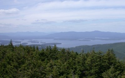
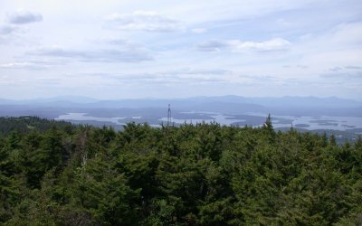
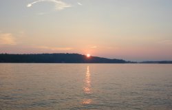
View from Mount Belknap
 NEW FOR 2022 – iPhone and iPad are now re-supported thanks
to Stonegate Software
NEW FOR 2022 – iPhone and iPad are now re-supported thanks
to Stonegate Software
Stonegate Software, LLC, and Bizer Corporation have teamed up
to bring back a navigating app for your iPhone and iPad. This is the most detailed and trusted
map of Lake Winnipesaukee: The
Bizer map, combined with the GPS and navigation features of today’s hand
held devices.
Click
here to go to Stonegate Software’s web page.
Note: Stonegate
Software is currently working on an app for Android devices – WATCH THIS
SPACE
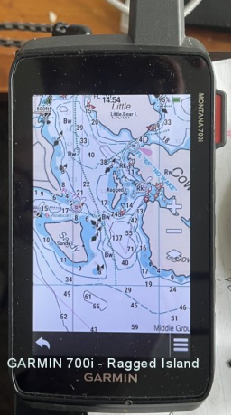
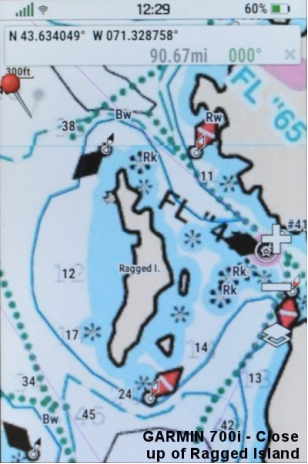
Garmin is back for
2022
Certain Garmin GPS units allow custom maps to be
installed. Most of these are
hand-held. For a complete list of
GPS units which allow custom maps, do an internet search for GARMIN DEVICES COMPATIBLE WITH CUSTOM
MAPS. Screen sizes range from
2.6” (66mm) to a whopping 6.95” (176mm). The images below are from Bizer’s
own Garmin Montana 700i (5”, 127mm screen) and Bizer’s GPSMAP 66sr
(3.0”, 76mm screen).
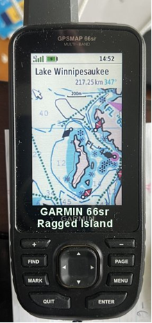
Go
to http://bizer.com/garmin for specifics,
pricing, and ordering information. ** We now
have Winnipesaukee pre-loaded onto Garmin DataCards,
SD cards, or MicroSD cards.
 NEW
FOR 2017 - A Lakes Region map for your wall
NEW
FOR 2017 - A Lakes Region map for your wall
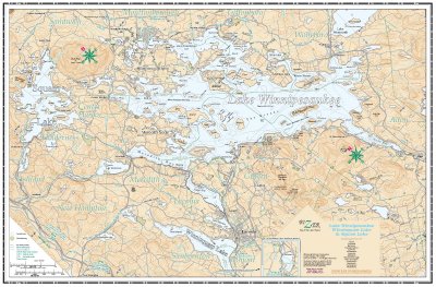
For 2017, Bizer is releasing a 21" x 31" map of the Lakes
Region. This new map would be perfect to hang on a wall in your
house. The map is 21" by 31" and can be purchased in paper or
laminated. The paper map, which has an price of
$9.95, may be framed. The laminated map, which has a suggested price of
$18.95, may be displayed on your wall without framing. Regardless of
which format you choose, we hope you enjoy Bizer's quality maps of the Lakes
Region.
Click here to see an enlarged version of
Bizer's Lakes Region map.
Bizer (rhymes with "geyser") charts have
combined state-of-the-art digital graphics with the precision of the Global
Positioning System to create superb, waterproof boating charts of Lake
Winnipesaukee and Lake Winnisquam. Some of Bizer's features include: 
- Buoy and rock positions that have been measured with
GPS surveying satellites to place buoys/rocks in their precise location
(+/- 35 feet). Bizer continues to have the
most precise buoy positions. Other maps of these lakes place buoys
in their approximate position and are as much as 550 feet in error.
- Almost four times as many charted rocks as other
charts.
- Bizer continues to have the
most accurate depth information of Lake Winnipesaukee and Lake Winnisquam.
All known areas less than six feet deep are marked in blue. Since
1996, only three boaters have shown us a shallow area less than five feet
deep that we overlooked. This information is vital to a navigator as
most boats have a draft less than five feet. This feature is not on
any other chart of these lakes.
- Bizer has accurate latitude
and longitude grid markings for use with GPS or LORAN. As a service
to our customers, the back of Bizer's folded Winnipesaukee chart has a
list of 250+ waypoints with their latitude and longitude.
- U.S. Geological Survey map accuracy standards are
that 90% of all data points (including buoys and rocks) be within 0.5 mm
(1/50 inch) of their true scale location. Only Bizer meets those standards.
![]()
Navigating on Lake Winnipesaukee is similar to navigating on the ocean as
well as most other lakes. Lake Winnipesaukee has shallow sandbars and
treacherous rocks just like everywhere else. This is why we decided to make our
chart similar to other marine charts.

Here's a list of some other pages:
- See our news page for changes / additions / corrections to our
chart of Lake Winnipesaukee.
- How high is Lake
Winnipesaukee? Bizer has a link to USGS daily statistics. Also
featured are Bizer's weekly statistics as
well as a graph of the last twenty years.
- How many islands are there
in Lake Winnipesaukee? Bizer has started to compile
a list and we invite you to share any news that you have on this topic.
- FAQ: Here are some frequently
asked questions
- Our
eleventh edition chart is available NOW. You can order directly
from BIZER
if you're paying by check. With a credit card, you can order our
charts from winnipesaukee.com.
- We have a page devoted to the enhancements, and corrections to our
Winnipesaukee chart.
- Bizer's chart of Lake
Winnipesaukee is available for sale at most
marinas around Lake Winnipesaukee. It is also available at many
book stores, gift stores, and bait & tackle shops. To find your
nearest dealer of any Bizer product, call
1-617-413-3940 or you can see a List of
vendors.
- BIZER has compiled a list of LAUNCH
SITES around Lake Winnipesaukee.
- HUNGRY? Here's a list of RESTAURANTS
and GROCERY STORES accessible by boat.
- Bizer has compiled a list of hotels
& motels that have docking for guests.
- We invite you to observe some of the differences between Bizer's chart of Lake Winnipesaukee and other maps.
- Here's a link to www.winnipesaukee.com, a source for various
information about Lake Winnipesaukee.
- The New Hampshire road tax of eighteen cents per gallon
is refundable to those who can show that the fuel was consumed in a boat
or other off-road vehicle. This page has a downloadable
copy of the refund forms for you to complete.
- Bizer has been using GPS on
Lake Winnipesaukee since 1992.
We get many questions and we have some products specifically designed for
your GPS. See our GPS web page. This
page also explains our waypoint file and other electronic forms of Bizer's chart, including
the C-Map chip to go into your GPS chart plotter.
< Last Updated 21-MAR-2020 >